


The Philippine Institute of Volcanology and Seismology or more commonly known to be PHIVOLCS, is the country’s department who takes charge in providing information and data on the activities of different natural disasters like volcanic eruptions, tsunamis, earthquakes, flooding, and the like.
In 2019, PHIVOLCS had launching different mobile applications that would help citizens in reducing risk for these disasters and how to mitigate them. One of which was PHIVOLCS FaultFinder.
Earthquake Tips: What to do before, during, and after

Loading...
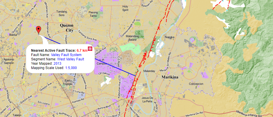
The PHIVOLCS FaultFinder is an application capable to do proximity searches to active faults. It may be used to determine the location of active faults in an area and to measure the shortest distance between an active fault and a user’s current location, which is determined by the gadget’s tracking device. It may also be used to measure the shortest distance between an active fault and a specific site, which is identified by a user.
 |
| PHIVOLCS FaultFinder |
The app would be useful for land-use planning, risk assessment, disaster risk reduction plan, and awareness. This web app is a product of the joint collaboration between the Philippine Institute of Volcanology and Seismology (PHIVOLCS), Department of Science and Technology (DOST), Geological Survey of Japan (GSJ), National Institute of Advanced Industrial Science and Technology (AIST), Japan. It was developed by Dr. Joel C. Bandibas of GSJ with the cooperation of the research and development personnel of PHIVOLCS.
The app uses three (3) base maps, Philippines Geoportal from NAMRIA, Google Maps, and Openstreet. Information about a particular query includes information on the Distance to the Nearest Active Fault, Fault Name, Fault Segment Name, Year of the Mapping, and Map Scale used during the mapping.If you are currently located, or if want to know the location of active faults, in the Greater Metro Manila Area (GMMA), click "Valley Fault System (VFS)" in the opening page, otherwise, click "Other Fault Systems".
 |
| PHIVOLCS FaultFinder |
To determine the distance of your current location to the nearest fault, turn on your gadget’s tracking device. Click the “VFS Fault Nearest You” or “Active Fault Nearest You”. You may click on “Active Fault Based on Location” tab if you want to know the distance of a Barangay to the nearest active fault. Or you may choose “Double Click a Place on the Map” and double click your cursor on any area of interest. You may click “Base Maps” located at the upper rightmost corner of the map, to change maps. Click “Legend” located at the lower rightmost corner of the map to see the legend.
PHIVOLCS takes the necessary steps to continually improve the accuracy of the fault information reflected in this application. The institute does not guarantee information from third-party sources. The public is advised to consult PHIVOLCS directly for official hazards assessment.
EMERGENCY KIT AND ESSENTIALS
Here are the best options to shop for your emergency kit and life essentials:
Shopee is my go-to app for things I needed like the ones above. If you'd like discounts and vouchers, you may get the best offers here:
RELATED INFO
- THE BIG ONE: What is West Valley Fault Line and What We Need to Do if it Happens
- Get the latest earthquake updates and volcanic activities from PHIVOLCS!
- List of Barangays in Metro & Greater Manila Areas near East and West Valley Fault Systems


No comments
Let us know your thoughts!