Showing posts with label Train. Show all posts

Commuters on Metro Manila's busiest railway can now experience a faster, more convenient way to travel. The Department of Transportation (DOTr) today officially launched cashless payment options for the MRT-3, marking a significant upgrade in the urban transit system and positioning it as a pioneer in seamless payment technology.


DOTr Secretary Vince Dizon led the unveiling at the MRT-3 Ayala Station, personally demonstrating the ease of the new system. He highlighted that commuters can now simply tap their debit or credit cards directly at the gates or, for e-wallet users, generate a QR code from their mobile apps for scanning.


"There is no additional fare here," Secretary Dizon assured commuters. "The system is, whatever is deducted from your GCash, your credit card, your debit card, it is the same as if you bought a single journey ticket."


Loading...

This innovative payment setup is touted by the transport chief as the first of its kind globally, capable of accepting both Near Field Communication (NFC) taps and QR codes from a single terminal. The DOTr also announced plans to extend these same cashless options to LRT-1 and LRT-2 lines in the near future, with the support of GCash and RCBC.


How to Use GCash at MRT-3 Gates

For the millions of Filipinos who rely on e-wallets, paying for their MRT-3 ride using the GCash app is now remarkably straightforward:

STEP 1 - Open your GCash app: Ensure you have the latest version installed on your smartphone.


STEP 2 - Look for "Commute" and tap it: This dedicated icon simplifies access to the QR ticketing feature.

STEP 3 - A QR Code will appear: This unique code is your digital ticket.

STEP 4 - Tap or scan your QR Code at an MRT-3 entry gate: Simply present your phone screen with the QR code to the designated scanner.


STEP 5 - The gate will open: Proceed through the turnstile.

STEP 6 - Do the same at the exit gate: The process is identical for exiting the station, ensuring your fare is correctly calculated.


Important Note: Your GCash account must have a minimum balance of ₱28 to successfully use the Commute QR code feature. For added convenience, users can also download a copy of their Commute QR for subsequent gate uses.


Wide Range of Participating Banks

Beyond GCash, the DOTr confirmed a broad list of banks supporting the MRT-3's new cashless payment method, offering flexibility for cardholders:


  • GCash: Visa (Debit), QR Code
  • Landbank: Mastercard (Debit/Credit), Visa (Debit)
  • BPI: Visa (Debit/Credit)
  • BDO: Mastercard (Credit), Visa (Debit/Credit)
  • HSBC: Visa (Debit)
  • GOTyme: Visa (Debit)
  • Union Bank: Visa (Debit)
  • RCBC: Mastercard (Debit/Credit), Visa (Debit)
  • Metrobank: Mastercard (Credit)
  • Security Bank: Mastercard (Credit)
  • Maya: Visa (Debit/Credit)
  • Chinabank: Mastercard (Credit)


This expansion of payment options is expected to significantly reduce queuing times, improve efficiency, and enhance the overall commuting experience for MRT-3 passengers, ushering in a new era of modern urban transportation in the Philippines.

You Can Now Pay For Your MRT-3 Ride Using Your GCash App!


Tucked away in the misty mountains of Wulai District, New Taipei, lies one of Taiwan’s most unique and charming attractions: the Wulai Log Cart (烏來台車)


Once used to haul timber during the Japanese colonial period, this narrow-gauge mini-train now serves a different purpose—taking curious travelers on a short but scenic journey through the forest, alongside a rushing river, and straight toward the famous Wulai Waterfall.

Wulai Falls as seen from Log Cart terminal

In this blog, we’ll take you aboard the Wulai Log Cart, explain how to ride it, and share why it’s worth including in your Wulai day trip itinerary.

Visit my Wulai Travel Guide to know how to get to Wulai from Taipei.

Loading...

A Historic Ride Through Nature

The Wulai Log Cart isn’t just a tourist gimmick—it’s a living piece of Taiwan’s industrial history. Originally built in the early 20th century to support the area’s thriving logging industry, these narrow rail tracks were once filled with carts hauling Formosan cypress and camphor trees.

Wulai Log Cart Welcome Signage

Today, they’ve been lovingly preserved and adapted to carry people instead of timber.

🛤️ Distance: Around 1.5 km

🚋 Duration: ~5 minutes one-way

🎟️ Fare: NT$50 per person (one-way)

📍 Route: From Wulai Old Street to Wulai Waterfall (or vice versa)

Wulai Log Cart Old Street Terminal

While the ride is short, it’s full of charm. The train clanks and rattles as it moves slowly along the tracks, hugging the curves of the riverbank.


As you ride, you’ll pass lush trees, steep ravines, and occasional mist drifting in from the waterfall up ahead.


Where to Board the Log Cart

There are two stations:

  • Wulai Station (Old Street Terminal) – Located near the end of Wulai Old Street, next to a small plaza.

  • Waterfall Station (瀑布站) – Situated beside the viewing area for Wulai Waterfall and near the Yun Hsien Cable Car.

Wulai Log Cart Old Street Terminal in the morning

Most people ride the cart from Old Street to the Waterfall, and walk back on foot to enjoy the riverside scenery at a slower pace.

The railway is parallel to Pubu Road where you can also walk

📌 Tip: If you want to skip the uphill walk to the waterfall, take the cart going one-way uphill and walk down later—it’s easier on the legs.


Riding Wulai Log Cart

Each log cart has multiple open-air passenger cabins, each just wide enough for 2 people to sit side by side but can accommodate up to 10 passengers. The track is narrow and the cabins are small, but that’s part of the appeal—it feels like stepping into a vintage amusement ride set deep in the woods.

Wulai Log Cart at Waterfall Station

As you depart from the station, the track runs alongside the turquoise Nanshi River (南勢溪), offering views of rapids and boulders as the forest closes in around you. Birds call out from the trees and the air grows cooler as you climb in elevation.

Scenic view from the log cart

💡 Photography tip: Sit on the left side when going uphill to get the best view of the river and cliffs.


The gentle chugging of the cart and the clickety-clack of wheels on track add to the nostalgic vibe. It’s not fast, it’s not flashy—but it’s wonderfully relaxing.


Family-Friendly and Fun for All Ages

The Wulai Log Cart is especially popular with families and older visitors who want to enjoy the natural beauty of Wulai without doing too much walking. Kids love the open-air ride, and adults often appreciate the convenience of skipping the steep 20-minute hike from Old Street to the falls.


The ride is also wheelchair-accessible upon request, and the staff are friendly and helpful, often assisting guests with boarding and safety checks.

Waterfall Station


Is the Wulai Log Cart Worth It?

Yes, absolutely. For just NT$50, the Log Cart provides a unique experience you won’t find anywhere else in Taiwan. It’s a blend of history, nature, and fun—a ride that helps you appreciate how Wulai evolved from a timber town into a peaceful retreat.


Even if you’re only in Wulai for half a day, the Log Cart adds color and character to your itinerary. Combine it with the waterfall, the Yun Hsien cable car, and a stroll along Wulai Old Street, and you’ve got a well-rounded nature trip just an hour from downtown Taipei.

Visit my Ultimate Taiwan Travel Guide to know more about the country.

Wulai Falls


Final Thoughts: A Ride Through Time

The Wulai Log Cart is more than just transportation—it’s a journey through history, culture, and one of Taiwan’s most scenic landscapes. Whether you’re a train lover, a family traveler, or just someone seeking quiet moments in the forest, the Log Cart offers a gentle, memorable way to explore Wulai.


So next time you visit, don’t just walk—ride. Let the click of the wheels and the sway of the tracks take you back to a simpler time, one meter-gauge rail at a time.


Planning to spend a day in Wulai? Check out my day tour Wulai itinerary that includes Old Street, Log Cart, Waterfall, and the cable car to Yun Hsien Resort!

Visit my list of Frequently Asked Questions in Taiwan (FAQs) to learn more.


Riding the Wulai Log Cart: A Nostalgic Mini-Train Through Taiwan’s Forests


In a region where traffic congestion is part of daily life, Metro Manila’s railway system remains a lifeline for millions. Whether you're a daily commuter navigating the city’s chaos or a tourist exploring the capital for the first time, learning how to use the city's growing rail transit system can save you time, money, and stress.

From the legacy of the Philippine National Railways to the futuristic North–South Commuter Railway project, here’s everything you need to know to ride the trains of Metro Manila—today and in the years ahead.


Understanding Metro Manila's Current Rail Network

Metro Manila currently operates three main commuter rail lines: MRT-3, LRT-1, and LRT-2, with the aging PNR still servicing longer-distance trips into the southern suburbs.


Each line serves a unique corridor of the metropolis, with several interchange stations making transfers possible for cross-city travel.


The MRT-3: Your EDSA Express


The MRT-3 is one of the most vital train lines in Metro Manila, running along the infamous Epifanio de los Santos Avenue, better known as EDSA. This elevated line stretches from North Avenue in Quezon City to Taft Avenue in Pasay. It has 13 stations and links key business and shopping districts such as Cubao, Ortigas, Makati, and MOA.

MRT-3 on EDSA

Open from around 4:30 AM to 10:30 PM, the MRT-3 is a go-to option for commuters looking to avoid EDSA’s gridlock. Fares range from ₱13 to ₱28 depending on distance, and the line is fully integrated with the Beep Card system, which allows tap-in/tap-out convenience across other Metro Manila lines.


MRT-3 (Metro Rail Transit Line 3)

  • Route: North Avenue (Quezon City) to Taft Avenue (Pasay)

  • Stations: 13 stations along EDSA

  • Key Stops: North Avenue (SM North EDSA), Cubao, Shaw Blvd., Ayala, Taft

  • Train Type: Elevated, Light Rail

  • Fare: ₱13–₱28 depending on distance

  • Hours: ~4:30 AM to 10:30 PM

  • Best For: North-South commute along EDSA (bypassing traffic)

  • Tip: MRT-3 connects with LRT-1 (at Taft–EDSA via walkway) and LRT-2 (via Cubao)


Loading...

The LRT-1: A Ride Through Old and New Manila


The Light Rail Transit Line 1, more commonly called the LRT-1, is the oldest mass transit system in Southeast Asia. Operational since 1984, it runs from Roosevelt Avenue in Quezon City to Baclaran in Pasay City. The route cuts through key parts of Manila, including historical sites, universities, and busy commercial zones.

LRT-1

Stations such as Doroteo Jose, Central Terminal, and UN Avenue provide access to the heart of the city, while the EDSA station connects directly to the MRT-3 via a short walkway. Trains run every few minutes, and like the MRT, Beep Cards are accepted.

As of 2025, construction is ongoing for the LRT-1 South Extension, which will connect Baclaran to Niog in Cavite—a long-awaited expansion that’s expected to partially open by late 2025 or early 2026.


LRT-1 (Light Rail Transit Line 1)

  • Route: Roosevelt (Balin­tawak) to Baclaran

  • Stations: 20 stations

  • Key Stops: Monumento, Blumentritt, Doroteo Jose (near Recto), EDSA (near MRT Taft), Baclaran

  • Train Type: Elevated, Light Rail

  • Fare: ₱15–₱30

  • Hours: ~4:30 AM to 10:30 PM

  • Best For: Traveling between northern and southern Manila (Manila–Pasay–Caloocan)

  • Extension in Progress: LRT-1 South Extension Project (Baclaran to Niog in Cavite) is ongoing and expected to open partially by late 2025 or 2026.


The LRT-2: Linking East and West


LRT-2 is the shortest of the three lines, but arguably one of the most scenic. Stretching from Recto in Manila to Antipolo in Rizal, this east-west route serves the university belt, government buildings, and residential hubs like Marikina and Masinag.

LRT2 offers free rides on March 8, International Women’s Day
LRT-2

The ride is smooth, relatively less crowded, and features longer trains compared to LRT-1. LRT-2 also intersects with both MRT-3 (via Araneta Center-Cubao) and LRT-1 (via Doroteo Jose and Recto stations). It’s particularly useful for students and professionals commuting from the eastern suburbs into Manila.


LRT-2 (Light Rail Transit Line 2)

  • Route: Recto (Manila) to Antipolo (Rizal)

  • Stations: 13 stations

  • Key Stops: Recto, Legarda, Cubao (connects to MRT), Marikina, Antipolo

  • Train Type: Elevated and Underground combo

  • Fare: ₱15–₱30

  • Hours: ~5:00 AM to 9:30 PM

  • Best For: East-West routes (Manila to Marikina, Antipolo)

  • Tip: If you're visiting universities in Manila (e.g., UST, FEU), LRT-2 Recto is your go-to.


The PNR: A Glimpse into the Past—and Future


The Philippine National Railways, or PNR, still operates several diesel-powered trains that travel from Tutuban in Manila to Calamba in Laguna. Though slower and less modern than its light rail counterparts, PNR provides essential connectivity to southern Metro Manila, with stops in Sta. Mesa, Paco, Alabang, and beyond.

PNR

However, the PNR as we know it is slowly being phased out. In its place will rise one of the country’s most ambitious infrastructure projects—the North–South Commuter Railway (NSCR).


PNR (Philippine National Railways)

  • Route: Tutuban (Manila) to Calamba (Laguna), with stops in Paco, Sta. Mesa, Alabang

  • Fare: ₱15–₱60 depending on distance

  • Train Type: At-grade (street-level), older diesel locomotives

  • Best For: Budget long-distance travel south of Metro Manila

  • Note: PNR trains are slower and less modern. This line is slated for retirement once the NSCR (North–South Commuter Railway) becomes fully operational.


How to Transfer Between Lines

Metro Manila’s train system isn’t a unified subway like in Tokyo or Singapore—but there are key transfer points that make multi-line commuting possible. For instance, passengers can walk from MRT-3's Taft Avenue station to LRT-1's EDSA station, or switch from MRT-3 to LRT-2 at Cubao via Gateway Mall. LRT-1’s Doroteo Jose station also connects to LRT-2’s Recto station via a footbridge.

An LRT-1 train approaching EDSA via Taft Avenue Station

These connections aren’t always seamless, but they do allow commuters to switch directions without going above ground or taking other vehicles.


Fares and Tickets: What You Need to Know

All three major lines (MRT-3, LRT-1, and LRT-2) now use the Beep Card—a reloadable contactless smart card that lets you tap in and out without lining up for tickets each ride. A card costs ₱50 (reloadable at stations, convenience stores, and online via apps).

Fares range from ₱13 to ₱30 depending on distance traveled. PNR, meanwhile, still uses traditional paper tickets and charges ₱15 to ₱60 based on your destination.

Visit my LRT and MRT Fare Types Guide to learn more.


Big Changes Are Coming: Future Rail Projects

If you think Metro Manila’s current system is limited, you’re not wrong. But change is on the way, and it’s coming fast.


The North–South Commuter Railway (NSCR)


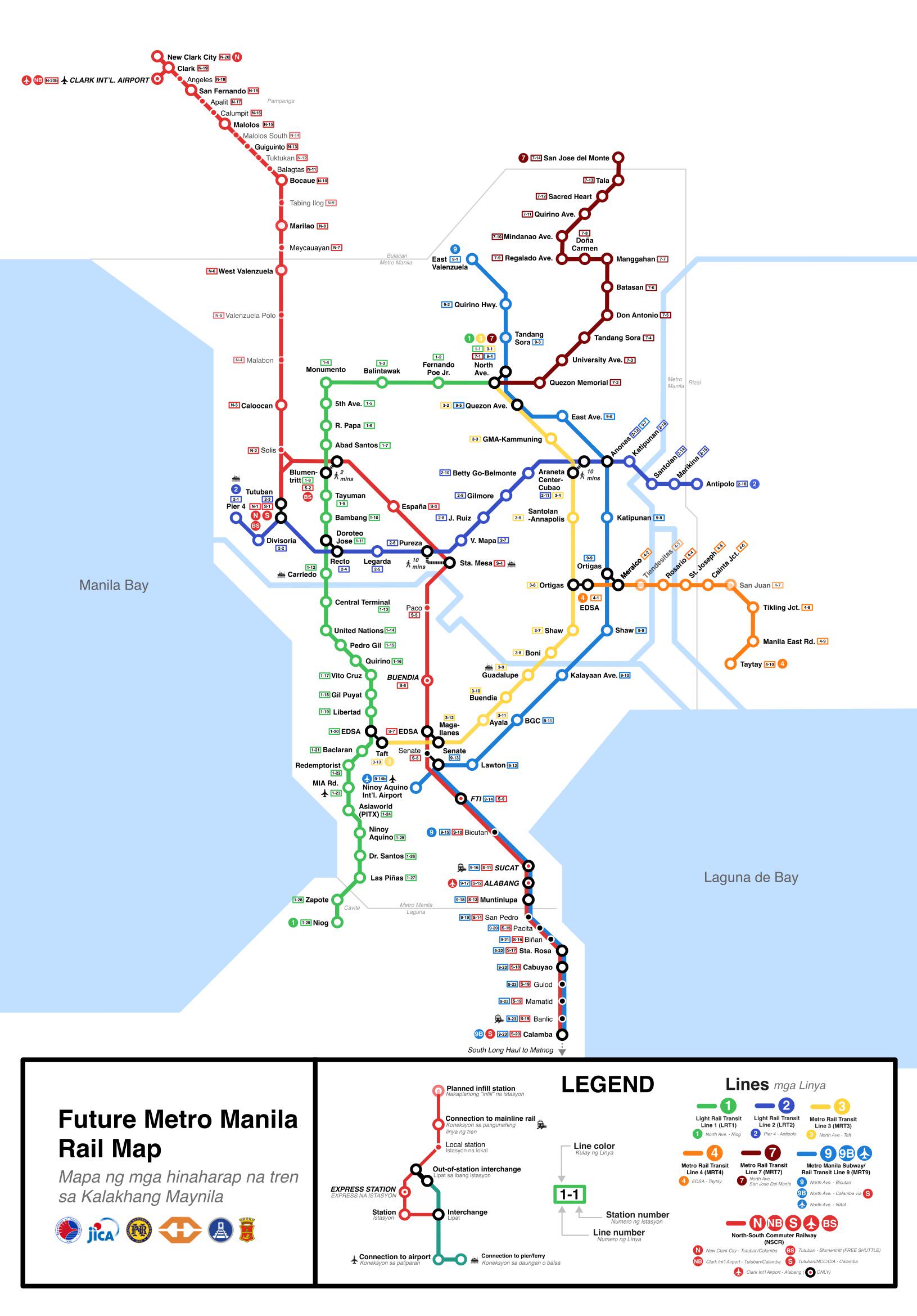
The NSCR is a game-changing project that will stretch over 147 kilometers—from Clark International Airport in Pampanga, through Metro Manila, down to Calamba in Laguna. The rail will be fully electric, modern, and designed for high-speed travel (up to 160 km/h). The Tutuban to Malolos segment in the north is expected to open by 2026 or 2027, with full operations targeted by 2029.

North–South Commuter Railway

Once complete, this new system will replace the aging PNR and integrate with LRT-1, LRT-2, MRT-3, and the Metro Manila Subway—forming the backbone of a fully connected urban rail network.


The Metro Manila Subway


Dubbed “the country's first real subway,” the Metro Manila Subway (also known as Line 9) will be fully underground and run from North Avenue in Quezon City to the FTI complex (now Arca South) in Taguig, with a spur line leading directly to NAIA Terminal 3. Construction is currently underway, and partial operations are expected by 2027.

Metro Manila Subway Project

This subway will dramatically cut travel time—what would normally be a two-hour journey by car from Quezon City to the airport will take just 35 minutes by train.


Tips for First-Time Commuters and Tourists

For tourists visiting Metro Manila, trains are not only fast but also a great way to see a slice of daily life. However, it’s important to plan ahead:

  • Avoid peak hours (6–9 AM, 5–8 PM) when possible, as trains can get extremely packed.

  • Keep your belongings secure in front of you, and use anti-theft bags if possible.

  • If you're a woman traveling alone, take advantage of the women-only train cars, available during rush hours.

  • Always bring a Beep Card, and top it up with at least ₱100 to cover round trips and transfers.

  • Check apps like Sakay.ph or Google Maps Transit to plan your routes in real-time.


Final Thoughts: A Changing Commute for a Growing Metro

Metro Manila’s train system is far from perfect, but it’s improving—and fast. With the NSCR and Metro Manila Subway on the horizon, commuters will soon have access to a modern, high-speed, and more reliable public transit system that rivals those of other Asian capitals.

In the meantime, navigating the MRT, LRT, and PNR remains a practical and budget-friendly option for both locals and tourists. With some planning, patience, and a Beep Card in hand, you’ll be able to get around the city’s urban sprawl with surprising ease.

As Metro Manila transforms, so will its transport—and in just a few years, hopping from Quezon City to Calamba, or from Makati to Clark Airport, could be as simple as riding one train.


Philippine National Railways

How to Utilize the Metro Manila Railway System (Commuting Guide for Tourists and Locals)


Whether you're flying into Taiwan for the first time or returning for another adventure, navigating Taoyuan International Airport (TPE) is easy thanks to a wide range of efficient, affordable, and well-connected transportation options. From high-speed trains and airport MRTs to long-distance buses and private taxis, here’s everything you need to know about getting from Taoyuan Airport to Taipei, Taichung, and other cities in Taiwan.


How Far is Taoyuan Airport to Taiwan Major Cities?

Taoyuan International Airport (TPE), Taiwan’s main international gateway, is located in the northwestern part of the island and is most conveniently accessible from Taipei, Taichung, and Kaohsiung—three of Taiwan's largest and most frequently visited cities.

Arrival at Taoyuan International Airport (T1)

Taipei, the capital city, lies just 40 kilometers away, making it a quick 40- to 60-minute drive or a 35- to 45-minute ride via the Taoyuan Airport MRT to Taipei Main Station.

Taichung, situated in central Taiwan, is about 150 kilometers from the airport. Travelers can reach it in roughly two hours by car or around 1.5 hours using the Taiwan High-Speed Rail (HSR) from Taoyuan HSR Station, including transfer time from the airport.

Kaohsiung, Taiwan’s major southern metropolis, is approximately 300 kilometers away and can be reached in 3.5 to 4.5 hours by car or just under two hours via HSR.

Loading...

Other cities are also accessible from Taoyuan International Airport. Hsinchu, a technology hub, is only about an hour away by car or 30 to 40 minutes by HSR. Further south, Tainan and Chiayi can be reached in 3 to 4 hours by car or a bit faster via high-speed rail. For travelers headed to Taiwan’s scenic east coast, Hualien and Taitung are more remote; while the straight-line distance may not seem far, the mountainous terrain means trips typically take 4 to 6 hours by car or train, often involving transfers through Taipei. Whether you're traveling for business, leisure, or exploring Taiwan’s cultural and natural wonders, TPE serves as a central hub for connecting to cities across the island.


🚆 Taoyuan Airport MRT (Metro) – Fastest Link to Taipei

The Taoyuan Airport MRT (Purple Line) is one of the most convenient and popular ways to get to Taipei Main Station.

Route: Taoyuan Airport (Terminals 1 & 2) to Taipei Main Station

Travel Time:

  • Express Train: ~35–40 minutes
  • Commuter Train: ~50–55 minutes

Frequency:

  • Express Train: Every 15–30 minutes
  • Commuter Train: Every 15 minutes

Operating Hours: 6:00 AM – 11:00 PM daily

Fare: NT$150 (one-way)

How and Where to Buy Tickets: Ticket machines, counters, or by using EasyCard/iPASS

🚉 Pro Tip: Express trains have special luggage racks and fewer stops—ideal for tourists with bags.


🚄 Taiwan High-Speed Rail (THSR) – Best for Long-Distance Travel

If you're heading to cities like Taichung, Tainan, or Kaohsiung, the Taiwan High-Speed Rail (THSR) is your best bet. While there’s no THSR station inside the airport, you can easily transfer via shuttle bus to the THSR Taoyuan Station.

Taiwan High Speed Rail (THSR) Taoyuan Station

Shuttle Bus to THSR Taoyuan Station


From: Airport Terminals 1 & 2

To: THSR Taoyuan Station

Travel Time: 20–25 minutes

Fare: NT$30

Frequency: Every 10–15 minutes

Schedule: 6:00 AM – 11:30 PM

Once at the THSR station, here are sample travel times and fares to popular cities:

  • Taipei (via THSR): 20 minutes | NT$160
  • Taichung: 60 minutes | NT$590
  • Tainan: 1 hr 40 mins | NT$1,190
  • Kaohsiung (Zuoying): 1 hr 50 mins | NT$1,490

🎫 Tickets can be purchased at THSR stations, online, or via vending machines.


🚌 Long-Distance Airport Buses – Budget-Friendly Option

Several reputable bus companies operate airport coaches to destinations across Taiwan. These are comfortable, air-conditioned buses perfect for budget-conscious travelers.

We caught a bus at 2am headed to Taipei Main Station. Fare was NT$133 per person.

Popular Routes from Taoyuan Airport


1. To Taipei

  • Operators: Kuo-Kuang, Evergreen, CitiAir Bus

  • Travel Time: 50–70 minutes (depends on traffic)

  • Fare: NT$140–NT$150

  • Schedule: Every 15–20 minutes from 5:30 AM to 12:30 AM


2. To Taichung

  • Operators: UBus, Kuo-Kuang

  • Travel Time: 2–2.5 hours

  • Fare: NT$270–NT$300

  • Schedule: Every 20–30 minutes from 5:30 AM to 11:30 PM


3. To Hsinchu

  • Operators: Kuo-Kuang, FreeGo Bus

  • Travel Time: ~90 minutes

  • Fare: NT$150–NT$180

  • Schedule: Every 20–30 minutes


4. To Tainan / Kaohsiung

  • Operators: UBus

  • Travel Time:
    • Tainan: 4.5–5 hours
    • Kaohsiung: 5–6 hours

  • Fare:
    • Tainan: NT$400–NT$500
    • Kaohsiung: NT$500–NT$700

  • Schedule: Limited; check company schedules online or at the counter

🚌 Where to Board: All airport buses depart from B1 bus terminals in Terminal 1 and Terminal 2

Here's my first hand experience on Traveling by Taoyuan Airport Bus to Taipei


🚖 Taxi – 24/7 Private Ride

Taxis are available 24/7 just outside the arrival halls. They offer the most convenient (but costly) option, especially if you’re traveling with luggage or during off hours.


To Taipei:

  • Travel Time: 45–60 minutes

  • Fare: NT$1,200–NT$1,500


To Taichung:

  • Travel Time: ~2 hours

  • Fare: NT$3,500–NT$4,000


To Kaohsiung:

  • Travel Time: ~4.5 hours

  • Fare: NT$6,000–NT$7,000

🚖 Tips:

Official taxis are metered and have clear signage.

Airport taxis are safe, and most drivers are familiar with popular destinations.


🚗 Private Transfers & Rideshare

If you prefer door-to-door service, you can book a private car service through platforms like Klook, KKDay, or hotel concierge desks. Some also use Uber, although coverage may be limited compared to taxis or MRT.

Cost:
  • Taipei: NT$1,200–NT$1,800
  • Taichung: NT$3,000–NT$4,000

Booking: Online (advance reservation recommended)

This is ideal for families, large groups, or those arriving late at night.


🧳 Luggage Delivery Services

Don’t want to drag bags around? Use luggage delivery counters at the airport to send your bags directly to your hotel or next city.

Providers: Yamato, LuggAgent, T-Express

Cost: ~NT$300–NT$500 per bag (depends on distance)

Delivery Time: Same-day or next-day


🌐 Final Thoughts: Choosing the Right Transportation from Taoyuan Airport


For Taipei visitors: The Airport MRT is your fastest, most convenient choice.

For Taichung, Tainan, Kaohsiung: Take the shuttle bus to THSR Taoyuan Station, then board a high-speed train.

On a budget? Go for long-distance buses—they’re cheap and reliable.

With luggage or kids? Consider taxis or private transfers for comfort and ease.

No matter your destination or travel style, Taoyuan International Airport offers seamless transportation links to every major city in Taiwan. With this guide, your journey to or from the airport will be smooth and stress-free.

Visit my Ultimate Taiwan Travel Guide to know more about the country.


Taoyuan International Airport Transfer Guide: How to Get to Taipei, Taichung & More (by Train, Bus & Taxi)


The LRT-1 Cavite Extension Phase 1 introduces five new stations, significantly enhancing connectivity between Metro Manila and nearby areas. 


Here’s a detailed guide on what to explore and access at each station:

Loading...

1. Redemptorist-Aseana Station

Redemptorist-Aseana Station

Key Destinations:

  • Baclaran Church: A historic Catholic shrine and pilgrimage site.

  • DFA Office of Consular Affairs: For passport and consular services.

  • Major Malls: S&R Aseana, Parqal Mall, Ayala Malls Manila Bay, SM Mall of Asia, and W Mall.

  • Entertainment City: Home to casinos, theaters, and hotels in Aseana City.

  • Transportation Hubs: Convenient access to LRT stations in Pasay, Manila, Caloocan, and Quezon City.


2. MIA (Manila International Airport) Station

MIA Station

Key Destinations:

  • NAIA Terminal 2: For domestic and international flights.

  • Ayala Malls Manila Bay: A shopping and lifestyle destination.

  • Palacio de Memoria: A cultural and historical estate for events and exhibits.

  • Residential Areas: Brgys. Tambo, Don Galo, and Vitalez in Parañaque; Pildera and Baltao areas in Pasay.


3. Asia World-PITX Station

Asia World-PITX Station

Key Destinations:

  • Parañaque Integrated Terminal Exchange (PITX): A central transport hub for buses, jeepneys, and other public transit options.

  • Marina Baytown: A developing area with leisure and business establishments.


4. Ninoy Aquino Station

Ninoy Aquino Station

Key Destinations:

  • NAIA Terminal 1: For international flights.

  • Shopping and Leisure: Duty Free Fiestamall, S&R Parañaque, Puregold Parañaque.

  • Educational Institutions: Parañaque Science High School, PUP Parañaque, St. Andrew’s School, St. Paul College.

  • Religious Site: Parañaque Cathedral.

  • Residential and Business Areas: Brgys. Sto. Niño, La Huerta, Moonwalk, Don Galo, northern San Dionisio, and Multinational Village.


ATTRACTIONS TO SEE IN MANILA 

Klook.com

5. Dr. Santos Station

Dr. Santos Station

Key Destinations:

  • SM City Sucat: A popular shopping mall in Parañaque.

  • Floriad Lifestyle Hub: A mixed-use development.

  • Villar SIPAG Complex: A community-oriented space.

  • Olivarez College and Schools: Educational institutions along Dr. A. Santos Avenue.

  • Residential Areas: Brgys. San Dionisio (southern), San Isidro, BF Homes, and San Antonio in Parañaque; Brgys. Manuyo Uno, Manuyo Dos, and CAA-BF International in Las Piñas.


Tips for Commuters


Plan Your Trip: Use the IkotMNL Mobile App for real-time schedules and fare information.

Stay Updated: Check for announcements on service updates or changes.

Explore Nearby Attractions: Take advantage of the proximity to malls, schools, and cultural landmarks.

Connect to Other Transit Options: Leverage the strategic location of stations for easy transfers to buses, jeepneys, and other modes of transportation.


These new stations not only enhance transportation efficiency but also bring commuters closer to key commercial, cultural, and residential hubs in Metro Manila and nearby areas.


Travel Guide to the 5 New Stations of LRT-1 Cavite Extension Phase 1