Showing posts with label PAGASA. Show all posts

The Department of the Interior and Local Government (DILG) announced on Monday that classes at all levels will be suspended in several parts of Luzon on Tuesday, July 22, 2025, due to persistent heavy rains brought by the Southwest Monsoon (Habagat).


The following areas will have no classes:

Loading...

Metro Manila

Zambales

Bataan

Pampanga

Bulacan

Cavite

Batangas

Rizal

Pangasinan

Tarlac

Occidental Mindoro


Rainy Day Essentials

Don't let the gloomy weather dampen your spirits! Here are some rainy day essentials to keep you cozy and prepared:


According to the DILG, the suspension was made in coordination with local government units (LGUs) and based on advisories from the Philippine Atmospheric, Geophysical and Astronomical Services Administration (PAGASA), as intense rainfall continues to pose risks of flooding and landslides.


Public Advisory


The public is advised to stay alert for further announcements from local authorities and PAGASA. Residents in affected areas are urged to stay indoors, avoid unnecessary travel, and monitor weather updates through official government channels.


Classes may resume once weather conditions improve and areas are deemed safe. Schools, parents, and students are encouraged to prioritize safety and preparedness during this time.


Classes Suspended in Several Luzon Areas on July 22 Due to Habagat Rains


As temperatures rise and summer sets in, the scorching heat becomes a common topic of conversation.


Yet, it's not just the thermometer reading that determines how hot it feels. The heat index, a combination of temperature and humidity, plays a crucial role in how heat affects our bodies and what precautions we need to take to stay safe.

RELATED: 10 Cold Places in the Philippines to Escape the Summer Heat

Loading...

Understanding the Heat Index

The heat index is a measure of what people perceive as the temperature affecting their bodies, accounting for both air temperature and relative humidity.

For example, in Dagupan City, Pangasinan, while the actual air temperature might reach 36.7°C, when combined with 62% relative humidity, the heat index soars to a staggering 51.7°C. This means that people in Dagupan "feel like" it's 51.7°C, emphasizing the significance of humidity in how heat is experienced.


Effects of the Heat Index

According to the Philippine Atmospheric, Geophysical, and Astronomical Services Administration (PAGASA), the heat index categorizes the level of caution needed based on the combined temperature and humidity:

  • 27°C to 32°C – Caution: Fatigue and heat cramps may occur with prolonged exposure and activity.
  • 33°C to 41°C – Extreme Caution: Heat cramps and heat exhaustion are possible, especially with continued activity.
  • 42°C to 51°C – Danger: Heat-related illnesses such as heat cramps, exhaustion, and stroke become likely, particularly with sustained activity.
  • 52°C and above – Extreme Danger: Heat stroke becomes imminent.


Impact of Sunshine

The heat index can be further exacerbated by exposure to sunlight. PAGASA warns that full exposure to sunshine can increase the heat index by an additional 8°C, intensifying the already sweltering conditions. This underscores the importance of seeking shade and staying hydrated, especially during peak sunlight hours.


Protecting Yourself

To mitigate the risks associated with high heat index values, it's essential to take proactive measures:

Stay Hydrated: Drink plenty of water to prevent dehydration, especially when engaging in outdoor activities.

Seek Shade: Limit exposure to direct sunlight and take breaks in shaded areas to cool down.
Dress Appropriately: Wear lightweight, loose-fitting clothing to promote ventilation and prevent overheating.

Take Regular Breaks: Avoid prolonged exposure to heat by taking frequent breaks indoors or in shaded areas.

Know the Signs: Be aware of symptoms of heat-related illnesses such as fatigue, cramps, dizziness, and nausea, and seek medical attention if necessary.

Visit PAGASA's latest reports and updates to know the weather, temperature and heat index in your area.

For class suspension, visit DepEd Class Suspension Guidelines.


ATTRACTIONS TO SEE IN MANILA 

Klook.com

Conclusion

As temperatures soar and humidity levels rise, understanding the heat index becomes increasingly important for safeguarding our health and well-being. By recognizing the impact of temperature and humidity on our bodies and taking appropriate precautions, we can stay safe and comfortable during the hot summer months. Remember, it's not just about the temperature – it's about how it feels, and being prepared can make all the difference.


READ MORE EXPLAINERS

What is Climate Heat Index? (EXPLAINED)


The Philippine Atmospheric, Geophysical and Astronomical Services Administration (PAGASA) plays a crucial role in keeping the public informed about weather conditions that may impact their safety and daily activities.


One of the essential tools PAGASA employs to achieve this is the issuance of rainfall warnings, designed to alert communities about potential flooding risks during heavy rainfall.


These warnings are categorized into three levels: YellowOrange, and Red, each based on the expected amount of rainfall within a specific timeframe. Understanding these advisories can significantly enhance community preparedness and response during adverse weather conditions.


Rainy Day Essentials

Don't let the gloomy weather dampen your spirits! Here are some rainy day essentials to keep you cozy and prepared:


Yellow Rainfall Advisory

The Yellow Rainfall Advisory is the first level of alert, indicating that the expected rainfall amount is between 7.5 mm and 15 mm within one hour. While this amount of rainfall might not seem alarming, it can still cause flooding in low-lying areas, particularly those with poor drainage systems. Communities receiving this advisory are advised to stay vigilant, monitor weather updates, and be aware of their surroundings. Taking early precautions can prevent potential hazards and allow residents to respond quickly if conditions worsen.


Orange Rainfall Advisory

The Orange Rainfall Advisory is a step up from the Yellow level and indicates a more severe weather situation. This advisory is raised when the expected rainfall amount ranges from 15 mm to 30 mm within one hour. Such heavy rainfall significantly increases the risk of flooding, especially in areas that are already prone to floods. Residents in these areas are advised to take immediate precautions, such as securing their homes, preparing emergency kits, and staying updated with the latest weather bulletins. Being proactive at this stage can help mitigate the impact of flooding on lives and properties.


Red Rainfall Advisory

The Red Rainfall Advisory represents the highest level of warning and is issued during emergency situations where heavy downpours pose a significant threat to life and property. This advisory is triggered when observed rainfall exceeds 30 mm within one hour or if rainfall surpasses 65 mm within the past three hours. In such scenarios, serious flooding is anticipated, and residents should prepare to evacuate to safer locations. Evacuation plans should be in place, and community shelters should be ready to accommodate affected individuals. The Red Rainfall Advisory demands immediate action and full cooperation from the public to ensure safety and minimize casualties.


Importance of Community Preparedness

Understanding PAGASA's rainfall warnings and the corresponding actions to take is vital for community preparedness. By staying informed and following the advisories, residents can better protect themselves and their properties from the adverse effects of heavy rainfall and flooding. Local government units (LGUs) and disaster response teams also play a crucial role in disseminating information, providing assistance, and coordinating evacuation efforts when necessary.

In conclusion, PAGASA's rainfall warnings are essential tools in safeguarding communities against the dangers of heavy rainfall and flooding. By recognizing and responding appropriately to the Yellow, Orange, and Red advisories, communities can enhance their resilience and ensure their safety during severe weather events.


What is PAGASA Rainfall Warning? (EXPLAINED)


According to the latest bulletin report, PAGASA says super typhoon Karding is moving closer to northern Quezon-southern Aurora area.

Polillo Islands and extreme northern Quezon province now under Signal No. 5.


Here's the latest update from PAGASA:

Loading...

EMERGENCY KIT AND ESSENTIALS

Here are the best options to shop for your emergency kit and life essentials:

Shopee is my go-to app for things I needed like the ones above. If you'd like discounts and vouchers, you may get the best offers here:

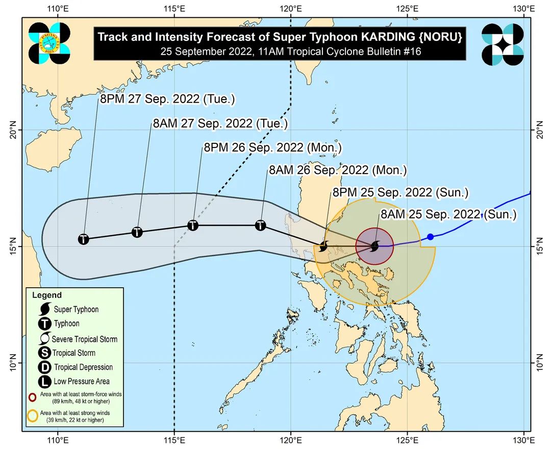
TROPICAL CYCLONE BULLETIN NO. 16

Super Typhoon "#KardingPH" (NORU)
Issued at 11:00 AM, 25 September 2022 
Valid for broadcast until the next bulletin at 2:00 PM today


SUPER TYPHOON “KARDING” INTENSIFIES FURTHER AS IT MOVES WESTWARD TOWARDS THE NORTHERN PORTION OF QUEZON – SOUTHERN PORTION OF AURORA


• Location of Center (10:00 AM)
The center of the eye of Super Typhoon KARDING was estimated based on all available data including those from Daet and Baler Doppler Weather Radars at 175 km East of Infanta, Quezon (15.0°N, 123.3°E)
• Intensity
Maximum sustained winds of 195 km/h near the center, gustiness of up to 240 km/h, and central pressure of 920 hPa
• Present Movement
Westward at 20 km/h
• Extent of Tropical Cyclone Winds
Strong to typhoon-force winds extend outwards up to 290 km from the center


TCWS No. 5
 > Wind threat: Typhoon-force winds
 > Warning lead time: 12 hours
 > Potential impacts of winds: Extreme threat to life and property

LUZON:
Polillo Islands and the extreme northern portion of Quezon (the northern and central portions of General Nakar, and the northeastern portion of Infanta)

• TCWS No. 4
 > Wind threat: Typhoon-force winds
 > Warning lead time: 12 hours
 > Potential impacts of winds: Significant to severe threat to life and property
 
LUZON:
Calaguas Islands, the southern portion of Aurora (San Luis, Dingalan, Baler, Maria Aurora), the northern portion of Quezon (the rest of General Nakar, the rest of Infanta, Real), the southeastern portion of Nueva Ecija (Gabaldon, General Tinio, City of Gapan, Peñaranda), the eastern and central portions of Bulacan (Doña Remedios Trinidad, Norzagaray, San Miguel, San Ildefonso, San Rafael, Angat, City of San Jose del Monte), the northeastern portion of Rizal (Rodriguez, City of Antipolo, Tanay, San Mateo, Baras), and the extreme northern portion of Laguna (Famy, Siniloan, Santa Maria, Pangil)
 
 • TCWS No. 3
 > Wind threat: Storm-force winds
 > Warning lead time: 18 hours
 > Potential impacts of winds: Moderate to significant threat to life and property

LUZON:
The central portion of Aurora (Dipaculao), the southeastern portion of Nueva Vizcaya (Alfonso Castaneda, Dupax del Sur, Dupax del Norte),  the rest of Nueva Ecija, Tarlac, the rest of Bulacan, Pampanga, Zambales, Bataan, Pangasinan, Metro Manila, the rest of Rizal, the northern and central portions of Laguna (Mabitac, Pakil, Paete, Kalayaan, Lumban, Cavinti, Pagsanjan, Luisiana, Majayjay, Magdalena, Santa Cruz, Pila, Liliw, Nagcarlan, Victoria, Rizal, City of San Pedro, City of Biñan, City of Santa Rosa, Cabuyao City, City of Calamba, Los Baños, Bay, Calauan), the northeasternn portion of Cavite (Bacoor City, Imus City, Kawit, City of Dasmariñas, Carmona, Gen. Mariano Alvarez, City of General Trias, Rosario, Silang), the rest of the northern portion of Quezon (Infanta, Real, General Nakar, Mauban), and the northern portion of Camarines Norte (Vinzons, Paracale, Jose Panganiban, Capalonga) 

Cheapest Flights and Airline Tickets Online Booking

• TCWS No. 2
 > Wind threat: Gale-force winds
 > Warning lead time: 24 hours
 > Potential impacts of winds: Minor to moderate threat to life and property

LUZON:
The southern portion of Isabela (Dinapigue, San Guillermo, Echague, San Agustin, Jones), Quirino, the rest of Nueva Vizcaya, Benguet, La Union, the rest of Aurora, the rest of Cavite, Batangas, the rest of Laguna, the central portions of Quezon (Calauag, Perez, Alabat, Quezon, Tagkawayan, Guinayangan, Sampaloc, Lucban, City of Tayabas, Lucena City, Pagbilao, Padre Burgos, Atimonan, Agdangan, Unisan, Plaridel, Gumaca, Lopez, Pitogo, Dolores, Candelaria, Sariaya, Tiaong, San Antonio, Macalelon, General Luna, Catanauan, Buenavista), the rest of Camarines Norte, the northern portion of Camarines Sur (Del Gallego, Ragay, Lupi, Sipocot, Libmanan, Pamplona, Pasacao, San Fernando, Pili, Minalabac, Ocampo, Tigaon, Cabusao, Magarao, Gainza, Canaman, Camaligan, Milaor, Naga City, Bombon, Calabanga, Tinambac, Siruma, Goa, Lagonoy, San Jose, Garchitorena, Presentacion, Caramoan, Sagñay), and Catanduanes
 
 
 • TCWS No. 1
 > Wind threat: Strong winds
 > Warning lead time: 36 hours
 > Potential impacts of winds: Minimal to minor threat to life and property
 
LUZON:
The southern portion of Cagayan (Tuao, Solana, Enrile, Tuguegarao City, Iguig, Peñablanca), the rest of Isabela, the southern portion of Apayao (Conner), Kalinga, Abra, Mountain Province, Ifugao, the southern portion of Ilocos Norte (Nueva Era, Badoc, Pinili, Banna, City of Batac, Currimao, Paoay, Marcos), Ilocos Sur, the rest of Quezon, the northern portion of Occidental Mindoro (Abra de Ilog, Paluan, Mamburao, Santa Cruz) including Lubang Islands, the northern portion of Oriental Mindoro (Puerto Galera, San Teodoro, Baco, City of Calapan, Naujan, Victoria, Pola, Socorro, Pinamalayan), Marinduque, the rest of Camarines Sur, Albay, Sorsogon, Burias Island and Ticao Island


HAZARDS AFFECTING LAND AREAS


Heavy Rainfall
• This morning through early afternoon: Moderate to heavy rains over Isabela, Aurora, Quezon including Polillo Islands, Catanduanes, Camarines Norte, Camarines Sur, and Isabela. Light to moderate with at times heavy rains over mainland Cagayan, Quirino, Nueva Vizcaya, Marinduque, Romblon, and the rest of Bicol Region. 
• This early afternoon through tomorrow early morning: Heavy to intense with at times torrential rains over Metro Manila, Zambales, Bataan, Tarlac, Pampanga, Nueva Ecija, Bulacan, Aurora, Rizal, and the northern portion of Quezon including Polillo Islands. Moderate to heavy with at times intense rains over Isabela, Nueva Vizcaya, Quirino, Benguet, Ifugao, Mountain Province, Pangasinan, Cavite, Laguna, the central portion of Quezon, and Camarines Norte. Light to moderate with at times heavy rains over Mindoro Provinces, Marinduque, and the rest of CALABARZON and Bicol Region.
• Tomorrow early morning through early afternoon: Heavy to intense with at times torrential rains over Zambales, Bataan, Pampanga, and Bulacan. Moderate to heavy with at times intense rains Metro Manila, Pangasinan, Cavite, Occidental Mindoro, and the rest of Central Luzon. Light to moderate with at times heavy rains over Mountain Province, Ifugao, Benguet, Quirino, Nueva Vizcaya, Oriental Mindoro, and the rest of CALABARZON.
• Under these conditions, scattered to widespread flooding and rain-induced landslides are expected, especially in areas that are highly or very highly susceptible to these hazard as identified in hazard maps and in localities with significant antecedent rainfall.
• Due to the Southwest Monsoon enhanced by KARDING, occasional to monsoon rains are also possible over Visayas and the rest of Southern Luzon, especially on their western sections. For more information, refer to the 24-Hour Public Weather Forecast issued at 4:00 AM today. Furthermore, the issuance of Weather Advisory for Southwest Monsoon is not ruled out.

Severe Winds
During the passage of KARDING, areas under Wind Signal No. 4 and No.5 will experience winds peaking at typhoon-force strength, while winds may reach storm-force in strength within any of the areas where Wind Signal No. 3 is hoisted. Gale-force conditions are likely any of the areas where Wind Signal no.2 is hoisted, while strong winds (strong breeze to near gale strength) will be experienced within any of the areas where Wind Signal No. 1 is currently in effect. 

Coastal Inundation
There is a high to very high risk of storm surge more than 3.0 m in height in the low-lying and exposed coastal areas of northern Quezon including Polillo Islands and Aurora. In addition, a moderate to high risk of storm surge is also possible over Camarines Norte, Pangasinan, Zambales, Bulacan, the northern portion of Metro Manila, the southern portion of La Union, and the rest of Quezon. The combined effects of storm surge and high waves breaking along the coast may cause life-threatening and damaging inundation or flooding. For more information, refer to Storm Surge Warning #2 issued at 11:00 AM today.

ATTRACTIONS TO SEE IN MANILA 

Klook.com

HAZARDS AFFECTING COASTAL WATERS

• Under the influence of KARDING, a marine gale warning remains in effect over the eastern and western seaboards of Luzon. For more information, refer to Gale Warning #3 issued at 5:00 AM. 
• In the next 24 hours, KARDING and the enhanced Southwest Monsoon will also bring moderate to rough seas over the northern and western seaboards of Luzon that are not under any gale warning (1.5 to 3.5 m) and the western seaboard of Visayas (1.2 to 2.5 m). These conditions may be risky for those using small seacrafts. Mariners are advised to take precautionary measures when venturing out to sea and, if possible, avoid navigating in these conditions.

ACTIVITIES AND TOURS IN MANILA


TRACK AND INTENSITY OUTLOOK

• Super Typhoon KARDING is forecast to track generally westward in the next 6 to 12 hours, then west northwestward for the remainder of the day. On the forecast track, KARDING will likely make landfall in the vicinity of the northern portion of Quezon or the southern portion of Aurora tonight. The possibility of an earlier (afternoon) landfall or close approach in the vicinity of Polillo Islands is not ruled out. 
• For the remainder of this evening post-landfall through tomorrow early morning, KARDING will traverse the landmass of Central Luzon and emerge over the West Philippine Sea via the coastal waters of Zambales or Pangasinan. The typhoon will then continue tracking generally westward over the West Philippine Sea for the remainder of the forecast period.
• KARDING is forecast to continue intensifying and may make landfall at or near a peak intensity of 185-205 km/h. Frictional effects during landfall and traverse of the Luzon landmass will weaken KARDING throughout the evening through tomorrow early morning, although it is highly likely that this tropical cyclone will remain a typhoon while crossing the landmass. 


Considering these developments, the public and disaster risk reduction and management offices concerned are advised to take all necessary measures to protect life and property. Persons living in areas identified to be highly or very highly susceptible to these hazards are advised to follow evacuation and other instructions from local officials. For heavy rainfall warnings, thunderstorm/rainfall advisories, and other severe weather information specific to your area, please monitor products issued by your local PAGASA Regional Services Division.

The next tropical cyclone bulletin will be issued at 2:00 PM today.

Super Typhoon Karding puts Polillo Islands under Signal no. 5, Metro Manila under Signal no. 3