

Do you want to know the weather today or if there's a typhoon in the Philippines? This page is dedicated for the latest PAGASA weather update today.
PAGASA Weather Update
In a country like the Philippines, where weather conditions can change rapidly and often lead to adverse impacts, staying informed about the latest weather updates is crucial for ensuring safety and preparedness. The Department of Science and Technology (DOST) - Philippine Atmospheric, Geophysical, and Astronomical Services Administration PAGASA plays a vital role in providing real-time weather information, storm signals, and the latest reports to the public.
Here's everything you need to know about DOST PAGASA's weather updates today:
Loading...
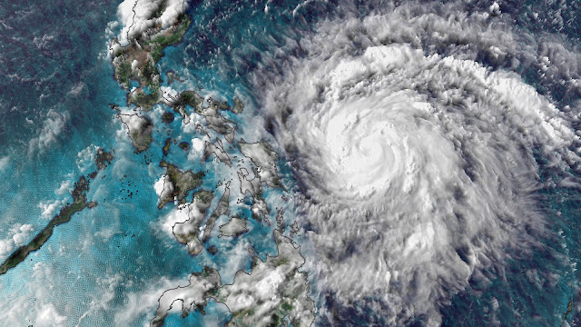
Real-Time Weather Monitoring
DOST PAGASA employs state-of-the-art technology and a network of weather monitoring stations to gather real-time data on atmospheric conditions across the Philippines. From satellite imagery and Doppler radar systems to automated weather stations, these tools enable meteorologists to track weather disturbances, monitor rainfall patterns, and forecast potential hazards accurately.
Get the latest weather updates from DOST PAGASA now!
 |
| PAGASA Weather Update Today |
What is the public storm warning signal?
Public Storm Warning Signals are raised to warn the public of incoming weather disturbances. Once a Storm Signal is raised, conditions are not yet necessarily felt in the given area. The following are the lead times for issuing a Public Storm Signal:
- The weather disturbance is expected in 36 hours once Public Storm Warning Signal No. 1 is raised.
- The weather disturbance is expected in 24 hours once Public Storm Warning Signal No. 2 is raised.
- The weather disturbance is expected in 18 hours once Public Storm Warning Signal No. 3 is raised.
- The weather disturbance is expected in 12 hours once Public Storm Warning Signal No. 4 is raised.
Lead time shortens if a new weather bulletin is issued and the area’s Public Storm Signal Warning remains the same.
As the weather disturbance moves through the Philippine Area of Responsibility (PAR), Public Storm Signals may be upgraded or downgraded.
An area’s given signal number is based on the intensity, size of circulation and the forecast direction, and speed of the tropical storm or typhoon when the Public Storm Warning Signal is raised. Changes in intensity, size of circulation, or movement of the tropical cyclone also determines the change of the Public Storm Warning Signal in a given area.
SUPER TYPHOON
Meteorological Conditions:
- A Super Typhoon will affect the area.
- Very strong winds of more than 220 kph may be expected in at least 12 hours.
Impact of the Winds:
- Almost total damage to structures of light materials, especially in highly exposed coastal areas.
- Complete roof failure on many buildings. Severe and extensive window and door damage.
- Most residential and institutional buildings of mixed construction may be severely damaged.
- Electrical power distribution and communication services severely disrupted.
- All signboards blown down.
- Total damage to banana plantation.
- Most tall trees are broken, uprooted, or defoliated.
- Coconut tress are stooped, broken, or uprooted.
- Few plants and tress survived.
Precautionary Measures:
- The situation is potentially extremely destructive or catastrophic to the community.
- All travels and outdoor activities should be cancelled.
- Evacuation to safer shelters should have been completed since it may have been too late for this situation.
- The area is very likely to be hit directly by the eye of the typhoon.
- As the eye of the typhoon approaches, the weather will worsen continuously, with winds increasing to its strongest coming generally from the north.
- A sudden improvement of the weather with light winds will be experienced, which means the area is under the eye of the typhoon.
- Depending on the eye’s diameter and movement speed, this improved weather may last for an hour or two.
- As the eye moves out of the area, weather conditions will worsen, with strong winds generally coming from the south.
- The disaster coordinating councils concerned and other disaster response organizations are now fully responding to emergencies and in full readiness to immediately respond to possible calamity..
EMERGENCY KIT AND ESSENTIALS
Here are the best options to shop for your emergency kit and life essentials:
Shopee is my go-to app for things I needed like the ones above. If you'd like discounts and vouchers, you may get the best offers here:

PAGASA WEATHER AND TYPHOON ALERTS
One of the primary responsibilities of DOST PAGASA is to issue timely warnings and advisories regarding tropical cyclones, typhoons, and storm signals. Through its official channels, including its website, social media platforms, and traditional media outlets, PAGASA provides updates on the location, intensity, and forecasted track of incoming storms. Additionally, the agency issues storm signals to alert residents in affected areas about the potential impact of the weather disturbance and advise precautionary measures to mitigate risks.
What is PAGASA rainfall warning?
PAGASA issues flood alerts to inform communities about potential flooding risks during heavy rainfall. These alerts are categorized into three levels: yellow, orange, and red, based on the expected rainfall amount within a specific timeframe.

Yellow Rainfall Advisory:
- Issued when the expected rainfall amount is between 7.5 mm and 15 mm within one hour.
- Communities receiving this advisory are advised to stay vigilant and be aware of the weather conditions.
- Potential flooding may occur in low-lying areas.
Orange Rainfall Advisory:
- Raised when the expected rainfall amount ranges from 15 mm to 30 mm within one hour.
- Communities under this advisory face a higher risk of flooding.
- Immediate precautions are advised, especially in flood-prone areas.
Red Rainfall Advisory:
- Issued during emergency situations when heavy downpours pose a significant threat.
- Occurs when observed rainfall exceeds 30 mm within one hour or if rainfall surpasses 65 mm within the past three hours.
- Serious flooding is anticipated, and residents should prepare to evacuate to safety.
How it Works:
- Check the advisory level issued for your area. For instance, residents of Marikina can access real-time flood information through Project NOAH.
- Visit the PAGASA website to view flood maps and flood inundation scenarios for Marikina River, updated every 10 minutes.
Latest Reports and Forecasts
In addition to typhoon updates, DOST PAGASA delivers comprehensive weather forecasts, including daily weather outlooks, rainfall forecasts, and temperature predictions. These reports provide valuable insights into expected weather conditions, helping individuals, communities, and government agencies make informed decisions and take necessary precautions to safeguard lives and property.
Public Engagement and Awareness
DOST PAGASA places a strong emphasis on public engagement and awareness, actively disseminating weather information through various channels to reach a wide audience. By leveraging social media platforms, mobile apps, and SMS alerts, PAGASA ensures that weather updates are accessible to all, including those in remote or underserved areas. Additionally, the agency conducts public information campaigns, workshops, and seminars to promote weather literacy and enhance community resilience to natural disasters.
ATTRACTIONS TO SEE IN MANILA
Klook.comFor earthquake updates, please go to PHIVOLCS page.
For traffic updates, please check our page for MMDA reports.


No comments
Let us know your thoughts!