


All you need to know about the Province of Apayao.
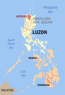
Apayao is a landlocked province in the Philippines in the Cordillera Administrative Region in Luzon. Kabugao serves as its capital. The provincial capitol and its associated offices are located at the New Government Center in Luna.

The province borders Cagayan to the north and east, Abra and Ilocos Norte to the west, and Kalinga to the south. Prior to 1995, Kalinga and Apayao comprised a single province named Kalinga-Apayao, which was partitioned to better service the needs of individual ethnic groups.
Loading...
FACTS ABOUT APAYAO

- Name in Ilocano: Probinsia ti Apayao; Tagalog: Lalawigan ng Apayao
- Location: 17°45′N 121°15′E | View Map
- Year Founded: 1995
- Capital: Kabugao
- Area: 4,413.35 km2 (1,704.00 sq mi)
- Population:
- Density: 27/km2 (70/sq mi)
- Division: Luzon
- Region: CAR
- Demonym(s): Apayao
- Elevation: 1,386 m (4,547 ft) (Mount Lambayo)
- Time Zone: PST (UTC+8)
- Zip Code: 3807–3814
- Area code: +63 -(074)-XXX-XXXX
- Electricity: Standard voltage is 220V.
- Plug commonly used is Type A but Types B and C are used as well.
- Bring A to B adapter(s).
- Currency: Philippine Peso (PHP)
- Exchange Rate: Approximately 1 USD = 50 PHP | click for exact exchange rate
- Income Class: Fourth Class
- Religion(s): 94% Roman Catholic
- Language(s): Ilocano, Isnag, Tagalog, English
- Known For: Philippine eagles, natural wonders
- Major Industries: Palay, corn, coffee, root crops, vegetables lanzones, citrus, bananas and pineapples, durian, santol, rambutan, coconut and mangosteen.
- Climate: Tropical
- Best Time to Visit: February
- Clothing: Casual light clothing: shorts, t-shirt, sandals. Light jacket and pants at night, at higher elevations, and boating.
- Airport(s): None
- Seaport(s): None
 |
| Apayao Provincial Capitol located in Municipality of Luna |
Before traveling, you might want to check the live weather forecast and updates to make your trip even easier and safer for you. You can also get the latest report for land traffic in Metro Manila and major parts of the Philippines.
WHAT TO PACK FOR APAYAO
Here are some things you might consider bringing with you for your day tour / adventure:
- Stylish face mask
- Water container/tumbler to rehydrate
- Sunscreen for skin protection
- Goggles for swimming or snorkeling
- Stylish Swimsuit
- Travel backpack / luggage
- Reusable vacuum storage packs
- Selfie stick
- Waterproof phone case
- Acion cam
- Camping tent
- WiFi kit
- Power bank
Shopee is my go-to app for things I needed like the ones above. If you'd like discounts and vouchers, you may get the best offers here:

APAYAO'S HISTORY
Apayao was established through Act No. 1642 on May 9, 1907 as a sub-province of Cagayan province.
The Americans established the Mountain Province on August 13, 1908, with the enactment of Act No. 1876. Apayao was incorporated; and along with Amburayan, Benguet, Bontoc, Ifugao, Kalinga, and Lepanto, became sub-provinces of this new province.
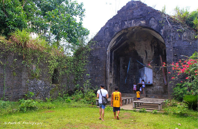 |
| Pudtol Church Ruins |
In the early years, the sub-province underwent series of territorial changes:
- Part of Apayao was transferred to the Province of Ilocos Norte (Executive Order 21, 1920).
- 1922: A barrio of municipal district of Bayag (now Calanasan) was transferred to Namaltugan.
- 1927: Parts of the municipal district of Pinukpuk in Kalinga were annexed to Conner.
- Through EO 200, approved on September 6, 1929, barrios in Tauit were organized into a separate municipal district, Luna, effective October 1.
- Through EO 13, approved on January 21, 1936, Tauit was abolished and was annexed as a single barrio to Luna, effective February 1.
- Through EO 78, approved on December 23, 1936, Namaltugan was abolished and was annexed to Bayag and Kabugao, effective January 1, 1937.
Kalinga-Apayao
On June 18, 1966, the huge Mountain Province was split into four provinces with the enactment of Republic Act No. 4695. The four provinces were Benguet, Bontoc (renamed "Mountain Province"), Kalinga-Apayao and Ifugao. Kalinga-Apayao, along with Ifugao, became one of the provinces of the Cagayan Valley region in 1972.
On July 15, 1987, the Cordillera Administrative Region was established and Kalinga-Apayao was made one of its provinces.
Finally, on February 14, 1995, Kalinga-Apayao was split into two independent provinces with the passage of Republic Act No. 7878.
 |
| Pudtol, Apayao |
Biodiversity & Biosphere Reserve
Apayao is biologically diverse. The province is sanctuary to 139 bird species, 61 of which are endemic and 4 threatened. It also has 43 species of wild food plants eaten by the indigenous people and 50 species of medicinal plants. The province is home to critically endangered rufous hornbills, lawaan or dipterocarp trees, Raflesia flowers, and the white-winged flying fox.
The Philippine Eagle Foundation began its search of eagles in Apayao in 2011 after reports of huge eagles were roaming the area for centuries. On March 22, 2013, scientists discovered the stronghold of critically endangered Philippine eagles, the country's national bird, in Luzon island within the vicinity of the Calanasan Lowland Forest.
On 9 July 2018, the provincial government of Apayao announced their intent for the province to be a UNESCO Biosphere Reserve. The province, which possesses more than 286,000 hectares of virgin forests, also noted that they have sent four of their personnel to train in the United States under the US Foreign Service to hasten the declaration of the site. On January 16, 2019, the provincial government announced that they were doing "legwork for the inscription."
 |
| Barangay Mataguisi, Pudtol, Apayao, Philippines. |
Tauit
Tauit (or Tawit), an Isneg settlement along the lower Apayao-Abulug River, was a former municipal district and Apayao's first sub-provincial capital (1907–1915) until the capital was moved to Kabugao in August 1915 by virtue of Executive Order No. 45. It had been existed by the time of creation of the sub-province of Apayao.
Tauit is said to be the forerunner of the present-day Pudtol. Its seat of government at Barrio Tawit was later divided into four barangays in the municipality.
Tauit was abolished through EO No. 13, issued on January 21, 1936 and effective February 1, with remaining territories annexed as a single barrio to Luna. These territories were established as the municipal district of Pudtol upon its creation on December 3, 1956 through EO No. 217.

GEOGRAPHY
The province of Apayao is located at the northernmost tip of the Luzon mainland. It is bounded on the east by the province of Cagayan, on the west by Ilocos Norte and Abra, and on the south by Kalinga. Total land area is 392,790 hectares or 21% of the total land area of the Cordillera Administrative Region (CAR).POLITICAL SUBDIVISIONS
Apayao is made up of seven municipalities with 131 barangays.- Calanasan
- Conner
- Flora
- Kabugao
- Luna
- Pudtol
- Santa Marcela
LANGUAGE/DIALECT
Ilocano is the dominant dialect spoken by almost half of the province's 26,812 households, followed by Isneg and Tagalog.CLIMATE
The prevailing climate in the province falls under Corona's Type III Classification. It is characterized by relatively dry and wet seasons, from November to April, and wet during the rest of the year. Heaviest rain occurs during December to February while the month of May is the warmest.INDUSTRIES
Updated records of the Department of Trade and Industry Provincial Office reveal that existing industries in the province are furniture, garment craft, food processing, gifts and house wares, and agricultural support. |
| Sunset in Barangay Swan and the Sleeping Beauty Mountain in the background |
ATTRACTIONS TO SEE IN MANILA
Klook.comTOURIST SPOTS TO SEE IN APAYAO
The following is a list of points of interest relating to the Apayao province:
- Agamata National Park and Wildlife Sanctuary
- Carmella Falls
- Lussok Crystal Cave
- Maton Underground River
- Maxibab Falls
- Mt Solo
 |
| Lussok Crystal Cave |
HOW TO GET TO APAYAO
From Manila, there are two bus lines travelling direct to Junction Luna in Abulog, Cagayan. The Florida Bus Line and RCJ Bus, The terminal of the two bus lines are located in Sampaloc, Manila. Travel time from Manila to Junction Luna is around 12 hours.
For detailed directions, fares and bus trip schedule, read my Manila to Apayao guide.
ACTIVITIES AND TOURS IN MANILA
FESTIVALS IN APAYAO
The following is a list of festivals celebrated in Apayao throughout the year:
- Fruit Harvest Festival (September and October) – Conner
- Say-Am Festival (February 14) – Pudtol
Frequently Asked Questions (FAQs) About Apayao
The following are the most frequently asked questions about the Apayao province.
- Where in the Philippines is Apayao located?
Apayao is located at the northernmost tip of Luzon. - Is Apayao a city or province?
Apayao is a province. - What is the Capital of Apayao?
The capital of Apayao is Kabugao. - What is Apayao famous for?
Apayao is famous for Philippine eagles.
OTHER PROVINCES IN CAR
Image of Apayao map Apayao map Feedback apayao capital apayao known for apayao city apayao tribe apayao products apayao language 7 municipalities of apayao


No comments
Let us know your thoughts!