


Luzon has an area of 104,688 square kilometers making it the largest island in the Philippines. Manila, the capital of the Philippines, is located in the main island group of Luzon.
Luzon sits at the northern end of the Philippines, and is the country’s largest and most populous island. It’s known for its mountains, beaches and coral reefs, and is home to Manila, the national capital.
 |
| Luzon Map |
Set on a deep bay with famed sunsets, the city has many Spanish-colonial landmarks, national memorials and monuments, a centuries-old Chinatown and a diversity of museums.
The Cordillera mountain range dominates North Luzon, with opportunities for hiking, mountain biking and caving. Within this region are Ifugao province’s famed rice terraces, carved into the landscape thousands of years ago, and Sagada, a backpacker town known for its limestone caves and hanging coffins.
To the southeast, the Bicol peninsula has Mt. Mayon and Mt. Bulusan, both active volcanoes, and the chance to snorkel with the butanding (whale sharks) of Donsol Bay. Also part of Luzon province are the world-class dive sites and tropical beaches of Palawan Island and Puerto Galera, on Mindoro Island.
Loading...
Travel Essentials
Here are some things you might consider bringing with you for your day tour / adventure:
- Stylish face mask
- Water container/tumbler to rehydrate
- Sunscreen for skin protection
- Goggles for swimming or snorkeling
- Stylish Swimsuit
- Travel backpack / luggage
- Reusable vacuum storage packs
- Selfie stick
- Waterproof phone case
- Acion cam
- Camping tent
- WiFi kit
- Power bank
Shopee is my go-to app for things I needed like the ones above. If you'd like discounts and vouchers, you may get the best offers here:

Philippine Regions and Provinces in Luzon
Here is the list of Philippine provinces in Luzon:
Cordillera
AbraApayao
Benguet
Ifugao
Kalinga
Mountain Province
Ilocos Region
Ilocos NorteIlocos Sur
La Union
Pangasinan
Cagayan Valley
BatanesCagayan
Isabela
Nueva Vizcaya
Quirino
Central Luzon
AuroraBataan
Bulacan
Nueva Ecija
Pampanga
Tarlac
Zambales
CALABARZON
BatangasCavite
Laguna
Quezon
Rizal
MIMAROPA
MarinduqueOccidental Mindoro
Oriental Mindoro
Palawan
Romblon
Bicol Region
AlbayCamarines Norte
Camarines Sur
Catanduanes
Masbate
Sorsogon
For Your Trip to the Philippines
How much does it cost to visit the Philippines? Click below to compare rates and discounts online:
Hotels
Tours & Activities
Essentials
Popular booked by other travelers

Luzon Regions
Here are the 7 administrative regions in Luzon, Philippines (not including NCR):
Ilocos Region (Region 1)
Ilocos is a region in the Philippines, encompassing the northwestern coast of Luzon island. It’s known for its historic sites, beaches, and the well-preserved Spanish colonial city of Vigan. Dating from the 16th century, Vigan’s Mestizo district is characterized by cobblestone streets and mansions with wrought-iron balconies. Further north, Laoag City is a jumping-off point for the huge La Paz Sand Dunes.
Regional Center: San Fernando, La Union
Area: 13,012.60 km² (5,024.19 mi²) this number will equal the total KM2 below
Cities: (9) Alaminos, Batac, Candon, Dagupan, Laoag, San Carlos, San Fernando, Urdaneta, Vigan
Languages: Ilocano (Iloko); Pangasinan; Bolinao; English
Major Industries:
- Crops (Palay, Corn, Banana, Mango, Tomato, Tobacco, Coconut)
- Food Processing
- Mass Transportation Operation
- Aqua Culture
- Mining
Cagayan Valley (Region 2)
Cagayan Valley, located in the northeastern section of Luzon Island, is an administrative region in the Philippines. It is composed of five Philippine provinces: Batanes, Cagayan, Isabela, Nueva Vizcaya, and Quirino.
 |
| Palaui Island in Sta. Ana, Cagayan |
Regional Center: Tuguegarao City (and the largest city)
Area: 28,228.83 km2 (10,899.21 sq mi)
Cities: (4) Cauayan, Ilagan, Santiago,Tuguegarao
Languages: Ilocano; Ibanag; Ivatan; Itawis; Gaddang; Yogad; Isinay; Ilongot; English
Major Industries:
- Crop (Palay, Corn, Sugarcane, Tomato, Peanut, Coffee, Coconut, Sweet Potato)
- Mining
- Milling
- Machineries
- Food Processing
Cordillera Administrative Region (CAR)
The Cordillera or CAR is a massive mountain range situated in the northern central part of the island of Luzon, in the Philippines and the only landlocked region in the country. It is bordered by the Ilocos Region to west and southwest, and Cagayan Valley to the north, east, and southeast.
 |
| A view of Baguio as seen in November 2012 |
Regional Center: Baguio
Cities: (2) Baguio City, Tabuk City
Area: 19,422.03 km² (7,498.88 mi²)
Languages: Ilocano; Bontoc; English
Major Industries:
- Crops (Palay, Corn, Banana, Mango, Tomato, Tobacco, Coconut)
- Minerals (Gold, Silver, Copper)
- Mining
- Textiles and Garments
- Handicrafts and Furniture
Central Luzon (Region 3)
Central Luzon, designated as Region III, is an administrative region in the Philippines, primarily serving to organize the 7 provinces of the vast central plains of the island of Luzon, for administrative convenience. The region contains the largest plain in the country and produces most of the country's rice supply, earning itself the nickname "Rice Granary of the Philippines".
 |
| Mount Pinatubo Crater in Zambales |
Regional Center: San Fernando (Pampanga)
Area: 22,014.63 km2 (8,499.90 sq mi)
Cities: (14) Angeles, Balanga, Cabanatuan, Gapan, Mabalacat, Malolos, Meycauayan, Muñoz, Olongapo, Palayan, San Fernando, San Jose, San Jose del Monte, Tarlac City
Languages: Kapampangan; Pangasinan; Sambal; Ilocano; English
Major Industries:
- Crops (Palay, Corn, Banana, Mango, Tomato, Tobacco, Coconut)
- Food Processing
- Mass Transportation Operation
- Aqua Culture
- Mining
CALABARZON (Region 4-A)
Designated as Region IV-A, the term CALABARZON came from the acronym of the five provinces within its scope: Cavite, Laguna, Batangas, Rizal, and Quezon. The region is formally referred to as Southern Tagalog Mainland.
Regional Center: Calamba (Laguna)
Area: 16,873.31 km2 (6,514.82 sq mi)
Cities: (20) Antipolo, Bacoor, Batangas City, Biñan, Cabuyao, Calamba, Cavite City, Dasmariñas, General Trias, Imus, Lipa, Lucena, San Pablo, San Pedro, Santa Rosa, Sto. Tomas, Tagaytay, Tanauan, Tayabas, Trece Martires
Languages: Tagalog; English
Major Industries:
- Crops (Palay, Corn, Banana, Mango, Coffee, Coconut, Sweet Potato, Pineapple)
- Food Processing
- Machineries
- Textiles and Garments
- Handicrafts and Furniture
- Aqua Culture
- Tourism
- Minerals (Gold, Silver, Copper, Nickel)
MIMAROPA (Region 4-B)
MIMAROPA, one of the two regions in the country without land border with another region, derived its name from the acronym of the five provinces it is composed of: Occidental Mindoro, Oriental Mindoro, Marinduque, Romblon, and Palawan.
 |
| El Nido, Palawan |
Regional Center: Calapan (Oriental Mindoro)
Area: 29,620.90 km2 (11,436.69 sq mi)
Cities: (2) Calapan, Puerto Princesa
Languages: Tagalog; Romblomanon; Bantoanon or Asi; Onhan; Cuyonon; Hiligaynon; English
Major Industries:
- Crops (Palay, Corn, Mango, Banana, Coffee, Sweet Potato, Pineapple)
- Food Processing
- Mining and Quarrying
- Natural Gas
- Handicraft and Furniture
- Aqua Culture
- Tourism
- Minerals (Gold, Silver, Copper, Nickel)
Bicol (Region 5)
Located in the southern part of Luzon Island is Bicol Region, also known simply as Bicol. It is composed of six provinces; four of which are within the Bicol Peninsula mainland while two are offshore.
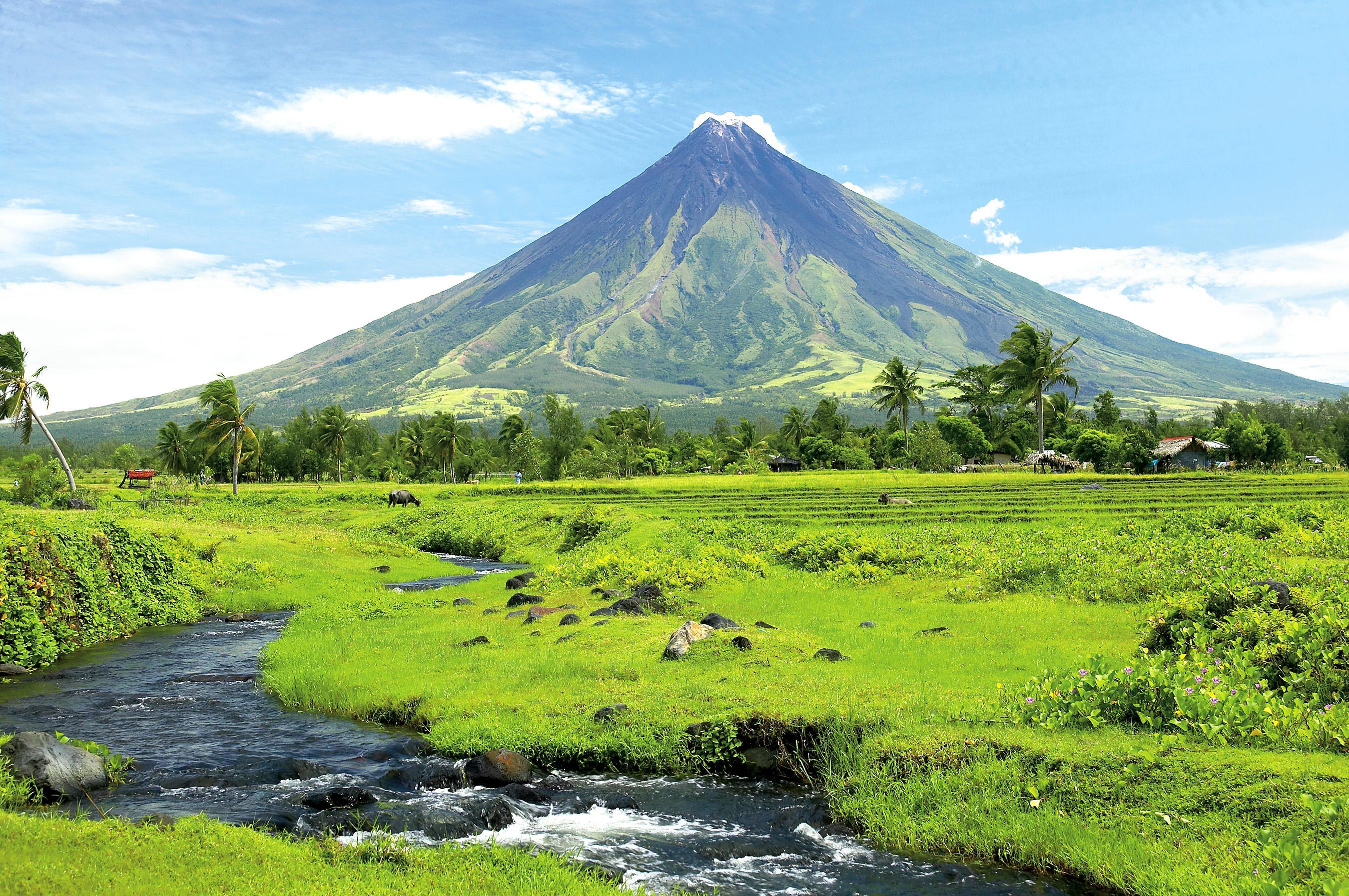 |
| Mayon Volcano |
Regional Center: Legazpi
Area: 18,155.82 km2 (7,010.00 sq mi)
Cities: (7) Iriga, Legazpi, Ligao, Masbate City, Naga, Sorsogon City, Tabaco
Languages: Central Bikol; Albayanon; Rinconada; Sorsoganon; Catanduanes; Masbateño; Kinaray-a; Waray-Waray; Tagalog
Major Industries:
- Crops (Palay, Corn, Banana, Jackfruit, Coconut, Pineapple)
- Food Processing
- Mining
- Aqua Culture
- Minerals (Gold, Silver, Chromite)
ATTRACTIONS TO SEE IN MANILA
Klook.comThe 38 Provinces in Luzon, Philippines
Listed in alphabetical order:
- Abra
- Albay
- Apayao
- Aurora
- Bataan
- Batanes
- Batangas
- Benguet
- Bulacan
- Cagayan
- Camarines Norte
- Camarines Sur
- Catanduanes
- Cavite
- Ifugao
- Isabela
- Ilocos Norte
- Ilocos Sur
- Kalinga
- Laguna
- La Union
- Marinduque
- Masbate
- Mountain Province
- Nueva Ecija
- Nueva Vizcaya
- Occidental Mindoro
- Oriental Mindoro
- Palawan
- Pampanga
- Pangasinan
- Quezon
- Quirino
- Rizal
- Romblon
- Sorsogon
- Tarlac
- Zambales
ACTIVITIES AND TOURS IN MANILA
Frequently Asked Questions (FAQs) About Luzon
- What are the 8 regions in Luzon?
- What is Luzon known for?
Luzon, largest and most important island of the Philippines. It is the site of Manila, the nation's capital and major metropolis, and of Quezon City. Located on the northern part of the Philippine archipelago, it is bounded by the Philippine Sea (east), Sibuyan Sea (south), and the South China Sea (west). - What are the four major areas of Luzon?
Having an area of 42,458 square miles, Luzon is further subdivided into four major areas — Northern Luzon, Central Luzon, Southern Luzon, and the National Capital Region, which is the country's center of economic, social, cultural, and financial development.Jan 20, 2018 - Does Palawan belong to Luzon?
Several outlying islands near mainland Luzon are considered part of the Luzon Island group. The largest include Palawan, Mindoro, Masbate, Catanduanes, Marinduque, Romblon and Polillo. - How would you describe Luzon?
Luzon is located in the western Pacific Ocean. It is the largest island in the Philippines and lies at the northern end of the island group. The lowland rain forests ecoregion comprises all the areas below 1,000 m on Luzon and a few isolated volcanic mountains in the south of the island that exceed 1,000 m.


No comments
Let us know your thoughts!