
 sierra madre (philippines provinces) sierra madre issue sierra madre ship sierra madre benefits how was sierra madre (philippines formed)")
This range of mountains has been protecting the Philippines to storms and super typhoons for years.
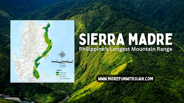
The Sierra Madre is the longest mountain range in the Philippines. Spanning over 540 kilometers (340 mi), it runs from the province of Cagayan down to the province of Quezon, forming a north–south direction on the eastern portion of Luzon, the largest island of the archipelago.
 |
| Sierra Madre in the Philippine map |
It is bordered by the Pacific Ocean to the east, Cagayan Valley to the northwest, Central Luzon to the midwest, and Calabarzon to the southwest. Some communities east of the mountain range, along the coast, are less developed and so remote that they could only be accessed by taking a plane or a boat.
Loading...
The country's largest protected area, the Northern Sierra Madre Natural Park, is situated at the northern part of the range in the province of Isabela.
The park is in the UNESCO tentative list for World Heritage List inscription. Environmentalists, scholars, and scientists have been urging the government to include the other parks within the Sierra Madre mountains for a UNESCO site that would encompass the entire mountain range from Cagayan to Quezon.

In the north, the range starts in the province of Cagayan and ends in the south in the province of Quezon. In the province of Nueva Vizcaya, the Caraballo Mountains lies between Sierra Madre and Cordillera Central.
The mountain range serves as a typhoon barrier, attenuating incoming typhoons from the Pacific Ocean before reaching the central mainland.
| Sierra Madre Mountain Range infographic |
The range's highest point is unclear, and several peaks are attributed as the highest. Mount Anacuao in Aurora province stands at 6,069 feet (1,850 m), while Mount Cetaceo in Cagayan is of similar altitude. However, an expedition in September and October 2012 to Mount Guiwan (Nueva Vizcaya) preliminarily measured an altitude of 6,283 feet (1,915 m) on the summit.
Sierra Madre Mountain Peaks
 |
| Mount Bintuod in Municipality of Alfonso Castañeda in Nueva Vizcaya |
Here's a list of highest peaks along the mountain range by elevation:
- Mount Bintuod - 6,339 ft (1,932 m)
- Mount Guiwan – 6,283 ft (1,915 m)
- Mount Mingan – 6,191 ft (1,887 m)
- Mount Anacuao – 6,014 ft (1,833 m)
- Mount Cetaceo – 5,981 ft (1,823 m)
- Mount Dos Cuernos – 5,856 ft (1,785 m)
- Salakot Peak – 5,699 ft (1,737 m)
- Mount Cresta – 5,062 ft (1,543 m)
- Mount San Cristobal – 4,882 ft (1,488 m)
- Mount Otunao – 4,803 ft (1,464 m)
- Mount Irid – 4,751 ft (1,448 m)
- Mount Batay – 4,596 ft (1,401 m)
- Mount Dos Hermanos – 4,557 ft (1,389 m)
- Mount Minalunad – 4,419 ft (1,347 m)
- Mount Oriod – 3,957 ft (1,206 m)
- Mount Palanan – 3,921 ft (1,195 m)
- Mount Cagua – 3,717 ft (1,133 m)
- Mount Etnora – 3,671 ft (1,119 m)
- Mount Lubog – 3,133 ft (955 m)
- Mount Sumag – 2,759 ft (841 m)
- Mount Batolusong 2,559 ft (780 m)
- Mount Mapalad 2,461 ft (750 m)
- Mount Daraitan – 2,425 ft (739 m)
- Mount Maynoba – 2,388 ft (728 m)
- Mount Masungki – 2,165 ft (660 m)
- Mount Binutasan – 1,844 ft (562 m)
- Mount Malauban – 1,024 ft (312 m)
Rivers in Sierra Madre
Here's a list of major rivers along the mountain range by length:
 |
| Cagayan River |
- Cagayan River 518 km (322 miles)
- Pampanga River 270 km (167.7 miles)
- Ilagan River 189 km (117 miles)
- Angat River 153 km ( 95 miles )
- Agos River 93.8 km ( 58.2 miles )
- Pinacanauan River 82.6 km (51.3 mi)
- Umiray River 80.6 km (50 miles)
- Palanan River 79 km (49 miles)
- Marikina River 78 km (48.2 miles)
- Abuan River 70 km (43.4 miles)
- Aguang River 52 km (32.3 miles)
- Kaliwa River 31.3 km (19.4 miles)
Waterfalls in Sierra Madre
Here's a list of known and famous waterfalls in Sierra Madre:
 |
| Daranak Falls in Tanay, Rizal |
- Daranak Falls, Tanay
- Eva Falls, Dona R. Trinidad
- Lucab Falls, Dona R. Trinidad
- Secret Falls, Dona R. Trinidad
- Talon Pari Falls, Dona R. Trinidad
- Talon Pedro Falls, Dona R. Trinidad
- 13th Falls, Dona R. Trinidad
- Verdivia Falls, Dona R. Trinidad
- Zamora Falls, Dona R. Trinidad
There must be more we have not named or known yet.
ATTRACTIONS TO SEE IN MANILA
Klook.comNational Parks in Sierra Madre
- Aurora Memorial National Park
- Biak-na-Bato National Park
- Fuyot Springs National Park
 |
| Biak na Bato National Park |
Other Protected Areas in Sierra Madre
- Amro River Protected Landscape
- Angat Watershed Forest Reserve
- Casecnan Protected Landscape
- Dinadiawan River Protected Landscape
- La Mesa Watershed Reservation
- Magapit Protected Landscape
- Northern Sierra Madre Natural Park
- Pantabangan–Carranglan Watershed Forest Reserve
- Peñablanca Protected Landscape and Seascape
- Quezon Protected Landscape
- Quirino Protected Landscape
- Simbahan-Talagas Protected Landscape
- Talaytay Protected Landscape
- Upper Marikina River Basin Protected Landscape
 |
| Upper Marikina River Basin Protected Landscape |
Active Volcanoes in Sierra Madre
Cagua Volcano, an active volcano in Cagayan province that last erupted in 1907.
ACTIVITIES AND TOURS IN MANILA
Indigenous and Remote Communities
Sierra Madre is home to Indigenous Dumagat-Remontado communities who have ancestral domain claims covering parts of the mountain range.
 |
| Indigenous Dumagat-Remontado |
Some coastal communities east of the Sierra Madre mountains, especially from Palanan, Isabela heading north to near the northernmost tip of mainland Cagayan, are remote and isolated with no roads connecting them to towns west of the mountain range.
Towns like Palanan, Divilacan and Maconacon, Isabela can only be reached by plane from Cauayan City or a boat ride from Aurora province, south of Isabela or from Santa Ana, Cagayan, north of the province. Ilagan City – Divilacan road traversing the Sierra Madre mountain is about to be completed.
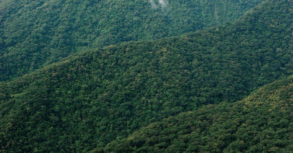
Sierra Madre Biodiversity
The Sierra Madre mountain range is rich in genetic, species, and habitat diversity, supplying food, water, and shelter to millions of people.
 |
| Aerial shot of Sierra Madre's portion in the Philippines |
The mountain range hosts multiple watersheds and some of the Philippines' oldest forests. These forests are some of the country's largest remaining forest blocks, including an old-growth dipterocarp forest, montane forests, and extensive lowland forests.
Sierra Madre's forests and watersheds are home to some of the country's richest wildlife communities. More than 291 species of birds and 25 endemic mammals may be found within the Northern Sierra Madre Natural Park alone.
Endemic flora and fauna
Northern Sierra Madre Natural Park, the largest protected area in Sierra Madre range, is home to endemic dipterocarp trees belonging to the Hopea and Shorea genera, orchids such as Dendrobium aclinia, the leguminous tree, Milletia longipes and a member of the citrus family, Swinglea glutinosa.
In the forest, in April 2010, the endemic lizard species Northern Sierra Madre Forest monitor lizard – Varanus bitatawa (common name: Butikaw) was described to science, although the Aeta and Ilongot indigenous peoples have known and used it as a food source. The Northern Sierra Madre forest monitor lizard is one of the three frugivorous lizards in the Varanidae family along with V. olivaceus and V. mabitang. All of the three frugivorous lizards are found only in the Philippines.
Endemic mammals in Sierra Madre are the Sierra Madre shrew mouse and Sierra Madre forest mouse.
Non-endemic flora and fauna
Narra, the national tree of the Philippines, Almaciga, and Kamagong can be found on the Sierra Madre range.
Isabela oriole, Philippine eagle, and Philippine crocodile are critically endangered species that can be found in fragmented locations.

Forest-loss due to anthropogenic activities
The Sierra Madre mountain range forest habitat is threatened by human activities. Settlers living at the lower portions of the slopes generally are supported by work in logging and charcoal-making. Some portions of the forest cover are already second growth forest. Forest degradation of at least 1,400 hectares per year caused by illegal tree cutting, slash and burn farming, fuel-wood collection, illegal hunting, and residential expansion.
Mining in Sierra Madre
A gold and copper mine in the municipality of Kasibu, Nueva Vizcaya, has been operated by the OceanaGold Corporation based in Australia. The Didipio mine is a large-scale open-pit mine in a remote location, and local residents claim the company has severely damaged both the environment for miles around the site, and suppressed the long-standing farming economy. Oceana continues to assert a right to operate despite expiration of its permit, and opposition by organized local residents, the Catholic Church, and worldwide environmental groups.
 |
| Up-close shot of Sierra Madre mountain range |
Hydropower Projects
The Kaliwa dam project through a project called "New Centennial Water Source" in Sitio Cablao, Brgy. Pagsangahan, General Nakar, Quezon / Sitio Queborosa, Brgy. Magsaysay, Infanta, Quezon is threatening the endangered species living in the sparse remaining forest of Sierra Madre and indigenous people's lives in that area. This project replaced the Kaliwa Low Dam that did not materialize and under the new administration, Rodrigo Duterte approved the Chinese-funded proposal.
Aside from the destruction of ecologically important forests, the dam also faces controversy for fulfillment of its financial requirement through a Chinese loan with a 2.0% interest rate rather than a Japanese loan with a 1.25% interest rate. The project continues to face strong opposition from the public yet the government is eager to continue. Construction of Kaliwa dam began in 2022.
Conservation Efforts
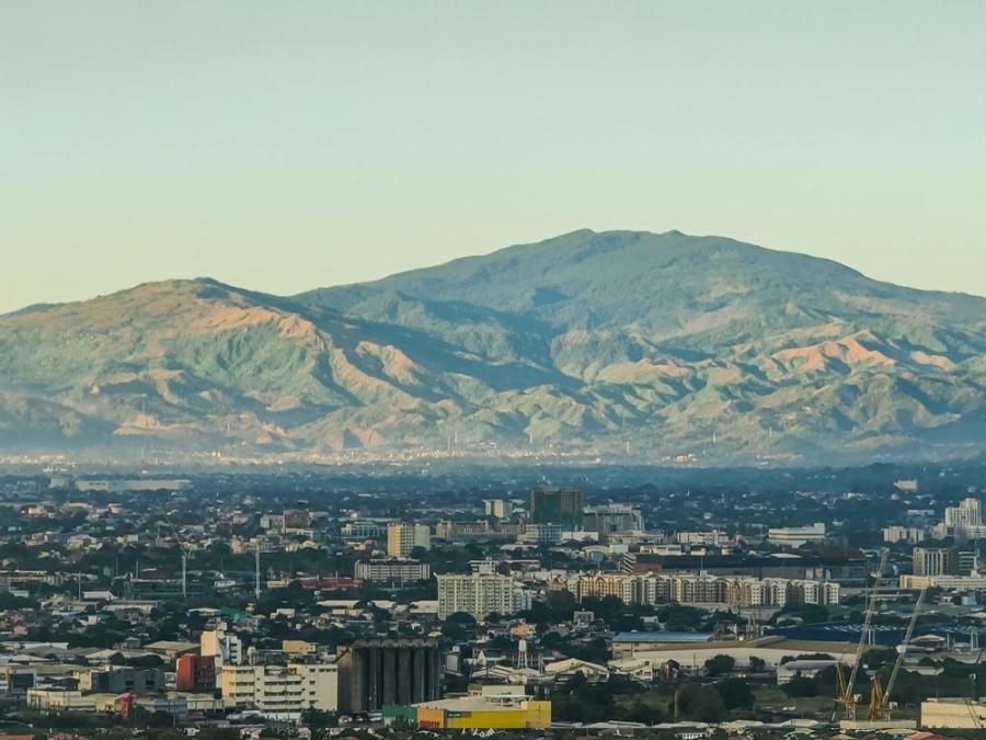 |
| A portion of Sierra Madre (Rizal area) as seen from Metro Manila |
The Mabuwaya Foundation is a non-governmental organization that aims to protect and conserve the Philippine crocodiles and other endemic threatened species. They mainly works in the towns of Divilican and San Mariano in Isabela.
Save Sierra Madre Day
On June 19, 2012, in light of the onslaught of Typhoon Ondoy on September 26, 2009, Philippine president Benigno Aquino III signed Proclamation No. 413, declaring every September 26 as "Save Sierra Madre Day" in an effort to raise awareness on the benefits that the Sierra Madre brings and the risks and dangers of neglecting it.
The proclamation also calls "all sectors of society and the government" to join hands in pursuing activities geared toward the conservation of the Sierra Madre, and to plan, prepare, and conduct activities in observance of Save Sierra Madre Day.
Frequently Asked Questions (FAQs) About Sierra Madre Philippines
- What is Sierra Madre known for?
The Northern Sierra Madre Natural Park (NSMNP) is considered one of the most important of the protected areas system of the Philippines. It is the largest protected area in the country and the richest in terms of genetic, species and habitat diversity. - Why is it called Sierra Madre?
The Spanish name sierra madre means "mother mountain range" in English. - How is Sierra Madre Philippines formed?
Regional geology study pointed out that the Luzon Central Cordillera and the Northern Sierra Madre were combined together as a single Eocene magmatic arc (= the Sierra Madre arc) before backarc spreading to generate the inter-arc Cagayan Basin in the Late Oligocene–Early Miocene. - Can you see Sierra Madre from Manila?
People living in the country's capital region have unimpeded views of the Sierra Madre mountain range.
sierra madre location sierra madre (philippines) sierra madre (philippines provinces) sierra madre issue sierra madre ship sierra madre benefits how was sierra madre (philippines formed) sierra madre mountain range tectonic plates involved sierra madre mountain range issue sierra madre mountain range deforestation sierra madre (philippines provinces) sierra madre mountain range philippines facts sierra madre mountain ranges is a result of what convergence how was sierra madre (philippines formed)


&p[summary]=This range of mountains has been protecting the Philippines to storms and super typhoons for years. The Sierra Madre is the l...&p[url]=https://www.morefunwithjuan.com/2022/05/sierra-madre-mountain-range-philippines.html&p[images][0]=https://blogger.googleusercontent.com/img/b/R29vZ2xl/AVvXsEiQzJiVyjSEqUDG-RW2ix3K5n4H582Xa0hC2i5ldvnGwt3ydzT4HkIcYEDjn7037U7uXE0ecAqsLUl47_8j_tilurnKqQQPUDixrnay3CFWtL_Ltl-YCVsT3MuIFT7QuMrDx2u7HFFrs7Cq4HutDTW23ucJNvBeje54O_-OQcu70mdYeZacdg5aQI_m/w640-h360/Sierra%20Madre%20Mountain%20Range%20Philippines.png)
No comments
Let us know your thoughts!